Tuesday, May 3, 2011

Day 7: July 10, 2009

It took us some time to get ready to leave on day 7 (second day in Glacier).  We had a great breakfast and decided to head across the park to see the Saint Mary area.  Our drive across was in better weather than our previous day's journey to Logan Pass.  Across the pass we ran into a bear jam, and finally saw what appeared to be a Black Bear a very long ways off the road.  We made it through and got to the Saint Mary Visitor Center.


You probably can't see it, but there is in fact a Black Bear in this picture.
  We spent a large amount of time at the Saint Mary Visitors' Center.  Jacob, Nathan, and Grandpa Gary were waiting on the rangers to get back from lunch so we could get a back country camping permit.  They did have a very  nice relief map with all the trails on it so we could see that it was NOT a good idea to try the trail up over Triple Divide Pass like Jacob wanted to do.  We decided on the remote trail to Upper Kintla Lake.  We did finally get our permit and headed down toward Two Medicine.

To get to Two Medicine, a person has to leave the park and then head back into the park.  Two Medicine was once the most visited part of the park due to the relative ease of getting there.  On our way back into the park toward Two Medicine, we stopped at Running Eagle Falls to take a very nice nature trail there.  It was one of the most amazing water falls we have ever seen.  It is refererred to sometimes as Trick Falls.  The trail is easy and beautiful, and there are many wild flowers along it as well.


Mason and Megan in front of Running Eagle Falls

Nathan, Kristin, Grandpa Gary, and Brynn looking at Running Eagle Falls

Nathan and Kristin on the trail, and maybe others up ahead.
After that hike we went on to Two Medicine Lake.  Grandpa Gary offered to pay for Nathan, Kristin, Jacob, and Megan to take a lake boat tour while he and Grandma Becky watched the kids.  So they went into the store while the rest got on the boat.  They had some huckleberry ice cream and some other treats while the tour was going on.

The tour was really cool.  Two Medicine Lake hasn't had a glacier feeding it for at least 50 years, and they can tell because of the lack of glacial sediment.  We saw some really nice views of mountains, meadows of Bear Grass, waterfalls, and even a frequently seen Mountain Goat high up on the steep side of Mount Sinopah (8271 feet).  We also learned that Bear Grass got its name when Louis (from the Louis and Clark expidition) saw a very large quantity of it in a meadow with a bear.

Back on land, we met back up with the others and headed out.  We saw a black bear right next to the road, but didn't get any really good pictures of it.  We also stopped and took a hike along another trail to a waterfall, but we can't remember the name.

Grandpa Gary and Brynn heading into the store

Megan and Jacob in front of Two Medicine Lake.  The main mountain in the picture is Mount Sinopah, and Rising Wolf Mountain can be seen...rising...to off camera on the right.

Grandma Becky, Grandpa Gary, Mason, and Brynn waving in the store.

It was supposed to be a nice picture....

Mountains south of the lake

A waterfall off Rising Wolf Mountain and a meadow full of bear grass

Mount Sinopah behind us on our way back

Grandpa Gary, Mason, and Brynn looking at "the other waterfall".  Mason was a bit too eager and we worried about him some.

A Black Bear in the trees.
From there we decided to all drive down around the south end of the park to see East Glacier.  East Glacier was beautiful.  After spending some time wondering the lodge and admiring the gardens, we went on back to Lake McDonald.  They had a lot of amazing Columbine at East Glacier (Jacob's favorite).

Grandpa Gary and Grandma Becky bought everyone pizza at Lake McDonald so we could get to bed and get an early start for our hike to Upper Kintla Lake the next day. The evening would have been good for a hot dog roast too though, it was beautiful.  And no rain.

East Glacier Lodge

Flowers in the gardens
Some of the Columbine
                                   
Mason in a teepee


Sunset over Lake McDonald

A wonderful ending to a wonderful day

Monday, May 2, 2011

Day 6: July 9, 2009

We got up pretty early on day 6 and headed into Glacier.  It took a bit to drive to the Avalanche Creek area where we were to meet with the rest of the family.  We drove around Lake McDonald and stopped off to look at the creek feeding the lake.

McDonald Creek

McDonald Creek
After a bit we saw Grandma Becky and Grandpa Gary, and then the rest of the family showed up.  The area was very busy and we waited for a long time for a camp site.  We had a couple but wanted to try to get enough in the same area for all of us.  We were fortunate to wind up with that setup so we could all be together.

After setting up camp we took a hike to Avalanche Lake.  It is a fairly easy hike, taking about an hour.  Jacob carried Brynn in the special pack Grandma and Grandpa brought, which also had room for water and food.  Avalanche Creek was beautiful.  We saw a deer along the path and stopped to watch it for a bit, and some workers were mending the path.  Grandpa Gary got in trouble for trying to help.  We think maybe they were afraid of injury law suits or something.

Avalanche Lake was also pretty and busy.  We took our time and relaxed there, eating crackers and drinking water.  Nathan and Kristin had some fancy California bread and cheese and they brought along some fruit snacks that Grandpa Gary loves.  It was a great time to soak up nature's beauty and have fun together.


One of Jacob's favorite pictures, Avalanche Creek was amazing

Granma Becky, Seth, Amanda, Jared, and Caleb (right to left)

It's not a good idea to feed the wildlife, but you can tell they are used to it and it is hard to avoid dropping crumbs.

Caleb and his boys out on a rock in the lake, with Mason

Avalanche Lake has many small melt waterfalls feeding it.
After hiking back to the campsite, we drove up the Going to the Sun Road.  What an amazing, breath taking, frightening road that is!  Jacob drove, and he wanted to look at the amazing views but it was hard enough to no have a nervous break down just looking ahead.  The road across the park is definitely easy on the eyes, but hard on the heart.  There is just so much to see there.  We stopped at a pull out early in the drive to walk off some shaky legs and enjoy the view.  Then we drove on to Logan Pass.


Jacob thinks this is part of Heavens Peak
Once at Logan Pass Caleb and his family, Nathan and Kristin, and Grandpa Gary headed up the Hidden Lake Trail.  Grandma Becky stayed at the Visitors' Center with Brynn in a stroller and Jacob, Megan, and Mason took off up the trail.  There was a lot of snow higher up on the trail, and we weren't prepared for it.  No snow poles and regular shoes make it tough to navigate snow pack up a steep slope.  Jacob had the best shoes for it but still slipped around a bit.  We saw a lot of Marmonts and it sprinkled some.  We even saw a rainbow as we turned and headed back down, not even close to the high point in the trail.  We had it on good report that Hidden Lake was very beautiful though.


There are always a lot of Mountain Goats at Logan Pass.  The mountain in the background is a true glacial horn; Clements Mountain, 8760 feet.

The view from Logan Pass looking back toward the west side of the park.


view from part way up the Hidden Lake Trail

Megan and Mason at one of the sections where you could still walk on the board walk

The rainbow after the short rain
It was clouding up again and getting late, so after looking around the center for a bit we decided to get Brynn and head back to camp to build a fire.  On our way back, we hit a bear jam.  There was a sow and at least one cub almost directly above our car, and plenty of people out taking pictures.  We didn't get to see them much but Jacob saw the cub and the sow's back.  But the sow was tossing rocks over and an extremely large rock landed between Megan's car's rear bumper and the car behind us.  It would have obliterated the trunk had it been a foot closer.  We yelled for the people to move and the traffic jam opened up quickly.  We were very shaky, especially Jacob who saw the rock falling while looking up through the sun roof.  But we were fortunate.

There wasn't any firewood at the camp so we drove to Lake McDonald to buy two bundles.  It was sprinkling by the time we got back to camp and Jacob started trying to build a fire while Megan started getting the kids ready for bed.  It started really raining about the time the rest of the family showed up and Grandpa Gary finished getting the fire going.  It was tough to eat in the pouring rain, but we had a good meal of hot dogs and went to bed.  Despite the cold and rain, it was a good day and the tent only leaked a little (Jacob had attempted to waterproof the seams before the trip).

Wednesday, April 20, 2011

Day 5, July 8, 2009

Day 5 was mostly a travel day.  We had to get to Columbia Falls, Montana by evening, and had no stops scheduled.  Jacob to the first shift, and we had a very difficult time finding our way to a store to buy batteries for the camera and breakfast.  We finally did; however, and then had a very hard time finding our way onto the proper freeway.  So it was a late start.  Yakima isn't very visitor friendly as far as signs and roads go.

Just outside of Yakima we got a very disant but interesting view of Mount Rainier and Mount Adams, although they were both still partially shrouded in cloud despite the clear skies.  The road to Montana was rather fast, so while we saw a lot of pretty country it is hard to remember and we took few pictures.  We did see a lot of farming and ranching operations, and discovered that they irrigate EVERYTHING in eastern Washington.  In one field they had circle irrigation set up, and where the irrigation fell we saw distinct green grass while immediately after the irrigation stopped the ground was dry, rocky, and covered with yucca.

Mount Adams in the distance (can you see it)

Mount Rainier in the distance

We did see a very neat valley after dropping off a tall mesa, and we saw a couple of crop dusters and a UH-1 Iroquoi military chopper.  We stopped in Spokane for lunch and met more horrid traffic as Megan took over driving and fought construction back to the interstate. 

We quickly made it to Idaho and started seeing a lot of pine trees and changing elevation.  The Coeur d'Alene area was especially pretty as we drove along the lake, but it was very busy also.  And it took us little time to get into Montana since the panhandle of Idaho is fairly narrow.

We left I-90 at St Regis, Montanta to try to cut off some of the distance.  That part of the day became pretty long and we had to make an emergency stop at a little gas station in some small town that we don't remember.  The people there didn't seem very friendly.  But we made it on to Ravalli and headed north toward our destination.

The end of our day was amazing, though we were very tired.  Flathead Lake was large and pretty, and we could see very abrupt mountain ranges off to the east.  We pulled into Columbia Falls and met up with Mom, Dad, Nathan, and Kristin at the Super 8 (I think that was what it was).  It was a very nice hotel with a rustic look.  We then met Caleb, Amanda, Seth, Jared, and Ethan at the A&W next door and had a great time.  Later we visited in Mom and Dad's room and made plans for our stay in Glacier which would start the next morning!

Rain over Flathead Lake

Mason having fun as we near Columbia Falls, Montana

Dramatic Mountains east of Flathead Lake

More beautiful mountains in western Montana

Tuesday, April 19, 2011

Day 4, July 7, 2009

Megan took the first shift driving out of Portland (or whatever part of Greater Portland we ended up in) toward the Pacific coast.  Our goal was to see the ocean and find a lighthouse.  The drive was a long one, much longer than anticipated.  It was wet just like you'd imagine in coastal Oregon and the scenic highway we were on was slow going.  Jacob thought it was pretty but the kids got tired and Megan wasn't too happy about driving for so long.

We finally made it to Tillamook and drove up the coast.  Even that got long looking for a beach.  We finally found Hug Point and made a stop.  It was very beautiful, and this year we even found a picture of it in Backpacker Magazine as a good place to stop.

Hug Point from the parking lot

Hug Point
Mason and Brynn loved playing in the waves and we saw a lot of Sea Gulls and some other birds.  Far to the North it appeared we could see a lighthouse, but we weren't for sure.  We looked in some caves and climbed some rocks and then had to leave.


Mason runs from the incoming surf

Brynn also runs from the waves.

This shot is almost identical to the one in Backpacker Magazine.

Triumphant pose.
We continued the long trek up the coast from there.  After quite a bit of driving, we found a small town with a beach.  Traffic was horrid, and we made it to the beach only to see a complete lack of a lighthouse.  So we fought traffic back out and continued on.  Oh, and the traffic wasn't heavy, it was really light, but the street was narrow and there were cars parked all over it.

Our next pit stop was Astoria, Oregon (HEY YOU GUUUUUUYYYYYSSSS!).  It didn't look anything like what Jacob thought it would, and it was crazy.  So instead of doing any sight seeing we stopped at a small gas station so Megan could get post cards and we managed to find a way up onto the giant bridge over the Columbia River channel (we drove under it but the streets were insane trying to get up to it).  But we made it into Washington only slightly behind schedule.

Megan was still driving.  The highway was slow and there wasn't much to see.  Jacob saw a Belted Galloway but didn't have his camera out.  We did make it to Longview, Washington (not a moment too soon) and ate at a Dairy Queen.  Jacob took over driving and we headed up to Mount Saint Helens.

Columbia River

Bridge over Columbia River from Astoria, Oregon to Washington
Mount Saint Helens was absolutely awe inspiring.  Jacob was once again impressed by something he wasn't so sure about seeing.  The perspective is so vast that it plays tricks on your ability to see things in scale, and the devastation is still very, very obvious.  It was a great stop for its beauty and for a reminder of the power of God's creation.


Jacob, Mason, and Brynn at Mount Saint Helens
Leaving Mount Saint Helens, we travelled back out (you have to go back out the way you came in which eats up a lot of time, but still worth it) and made our way toward Mount Rainier.  Jacob really wanted to see it, but unfortunately it was very cloudy and the east park entrance was closed.  So Jacob drove up through the mountains in hopes of catching a glimpse of it.

THAT road was scary.  The clouds didn't break, and we eventually wound up in them.  Furthermore, there were a lot of places where rocks had fallen on the road and where it appeared more were ready to do so at a moment's notice.  We happened upon a parking lot with bathrooms, and were thankful.  But we did indeed make it out of the mountains and had a very scenic drive through the evening into the drier part of Washington toward Yakima.  It would be a nice area to visit again, but we didn't have time to really sight see after that.


The closest we got to Mount Rainier

A mild picture of our point of view driving around the Mount Rainier area.
Dinner was Taco Bell in Yakima.  It was great, and the manager was very gracious and gave Mason and Brynn little comic books and colors.  Finding the hotel was very difficult; however, due to the street layout and naming in Yakima.  Beware.  But we made it to bed and tried to get rested for a long drive the next day.

Sunday, December 19, 2010

Day 3, July 6, 2009

 We got up early again and set out on our first "sightseeing" day.  Jacob took the first shift and once again we stopped to fuel up and get milk and donuts and the set off.  As we headed up The Dalles-California Highway along Upper Klamath Lake, we saw a nice mountain off to the west.  Megan looked it up and found Mount McLoughlin on the map.  The website mountainpeaks.net shows it at 9,344 feet tall.  Then, Jacob looked in the mirror and saw a giant hulk of snowy white back behind us.  Mason and Jacob got out to take pictures while Megan looked that one up.  She had to look all the way into California to find out that it was Mount Shasta, and nice 14,104 foot peak.  Then we headed on to Crater Lake.
Mount McLoughlin across Upper Klamath Lake

Mount Shasta from north of Klamath Falls
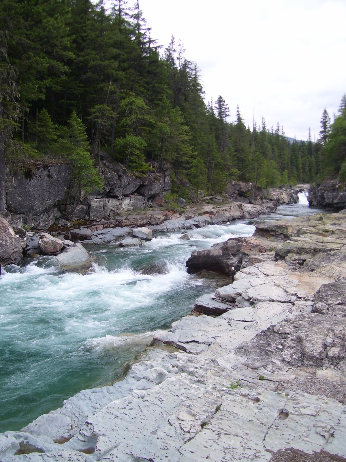
Crater Lake was great.  We made a few stops along the way for pictures, and finally realized we were driving around and slightly under the rim.  Once we made it to the parking lot on the rim, it was very cold and giant mosquitoes were everywhere.  Literally everywhere.  We couldn't escape them at all.  We made some bathroom breaks and put on some jackets, then waited for the Visitors' Center to open.  Then we walked over to the rim, which is about 1,000 feet above the lake surface.  The lake is absolutely stunning.  To think it is an old volcano that blew apart was amazing too.  And it is also the deepest lake in the United States.
Wizard Island on Crater Lake
Mount Shasta and Mount McLoughlin from the rim
We could have spent far more time at Crater Lake, and would have liked to have taken a boat tour.  Unfortunately, we had a lot we wanted to see and planned to make Portland for our stop that night.  So we stopped at the Watchman Overlook and then took the next road out of the park.

Working our way back to Highway 97, we then turned back north.  Our plan was to stop for fuel and food in Bend, Oregon.  Traffic got crazy as we neared.  Suddenly, off to the left there was a large cinder cone with cars spiralling toward the top, bumper to bumper.  It would have been neat to see but we weren't going to even think about it.  Jacob thinks Bend got its name from the road layout.  There wasn't a straight section of road that we could see, and none of the exits seemed to offer any fuel or food.  We finally just picked an exit, then nearly got lost on one single road that seemed to go every single direction.  It led us downtown, where pedestrians apparently have the right of way and we almost ran over an unfortunate man.  Whoops!  But eventually, we made it back to the highway and headed north toward Redmond.  Then was saw a gas station and pulled off.

And then Jacob made another mistake.  It's full service up there, and they don't like it if you try to pump your own gas.  But that allowed Jacob to try to figure out where food was, except the guy that pumped our gas couldn't speak English.  Luckily, the kids were still asleep and not crying out of hunger, because we were well past our scheduled time to stop by the time we hit the road again and pulled into Redmond.  On the north side of Redmond we found a very busy Taco Bell and stopped.

Off to the west of Bend, but very visible from the Taco Bell in Redmond, there are several pretty mountains.  They are referred to as the Three Sisters.

Mountains west of Bend, Oregon
Megan drove us out of Bend, and pretty soon we entered a much drier region.  We got some great views of Mount Jefferson, and then eventually Mount Hood, which was our next destination.  Mount Hood was shrouded in clouds as we approached.  We made it to Government Camp for some bathrooms, and then tried to figure out how best to view Mount Hood.  We finally drove up to the summit and Megan did an outstanding job of navigating the twisting road.

Mount Jefferson, 10,246 ft ASL
Mount Hood, shrouded in cloud
Summit from lower parking lot of lodge, Mount Hood, 11,161 ft ASL
After visiting the lodge for some purchases and to stretch the legs, we headed back down the mountain.  Jacob forgot to take pictures of the surrounding area while we were up so high.  After descending the mountain, we headed to Hood River.  We missed on great spot for pictures of Mount Hood, but stopped in the town of Mount Hood for a couple that really turned out great.
Mason posing in front of Mount Hood

The best view we actually captured of Mount Hood
The land was very pretty as we neared the Columbia River, but we were in a hurry at that point and didn't stop for any pictures.  Jacob tried to take some but we had so many bugs splattered on the car at that point, they didn't turn out very appealing.  But we finally made it to Hood River and took off along the Interstate that follows the river.  We stopped at the Bonneville Fish Hatchery based on Grandma Becky and Grandpa Gary telling us about it.  It was worth it and Mason loved seeing the Sturgeon and feeding Trout.  He was afraid of the stuffed bear though.
What seems to be the main building at the Bonneville Fish Hatchery
Brynn and Mason in front of one of the many beautiful gardens at the Hatchery

Mason looking at a huge Sturgeon
Mason feeding some Trout
Mason wasn't so sure about Jacob telling him to stand in front of this Black Bear
Jacob, Mason, and Brynn in front of the main building
Jacob decided to drive again after we left, and we took the old highway.  Jacob had read about Multnomah Falls and wanted to try to find it.  The drive was beautiful but we weren't seeing any waterfalls.  Suddenly, we found one.  In fact we found a bunch.  The first one was a pretty undulating falls named Horsetail Falls.  Mason and Jacob got out to look and take pictures.
Mason at Horsetail Falls
We got pretty close to Portland and finally found Multnomah Falls.  It was amazing.  It is the tallest waterfall in Oregon and the third tallest year round waterfall in the United States.  It is spring fed from off a mountain.  You can hike up part way to a bridge going over the brink of the lower falls and then hike up all the way to the top.  Jacob and Mason went up to the bridge for some pictures.  Then we jumped back on the highway to head to Portland.
Mason at Multnomah Falls
Portland was crazy.  We got lost.  We finally found a Taco Bell and the people there were so polite and helpful.  The manager asked where we were from and helped us with directions back to the highway and hotels.  The directions didn't help much, and we wound up driving for a while before we finally found an expensive looking cluster of hotels on the west side of Portland.  We don't think we were in Portland any longer, but who knows where we were.  We stayed at a Marriott with a weight room, hot tub, and pool.  Mason and Jacob swam for a bit and then we went to bed.  But we knew we were pretty close to Highway 26 which is what we wanted to hit the next morning to head to the coast, so all was good.